Monday, December 30, 2013

The Space Coast

Most of Florida's 1200 miles of coast is divided up into semi-official 'Coasts' for some reason. The most NE section is called First Coast and as you travel south the next section is the Space Coast, obviously because of the large impact that NASA facilities have here. So after departing Marineland this past Friday we have transitioned to the Space Coast.
 
On Friday, to catch favorable tidal currents, we waited until after 10 am to depart which gave us time to walk the dogs for a final time on the nature trail and to get Spray's holding tank pumped out. In spite of gray skies and moderate N winds we had easy traveling driving from the 'downstairs' helm. It was a longish 40 mile run down past Daytona Beach, ending at the Rockhouse Creek anchorage near Ponce de Leon inlet. We dropped anchor at about 5 pm and just had time to dinghy the dogs to a nearby small beach.
 
Early Saturday morning we visited that same beach for the same purpose and were surprised to find that at least 75 cannonball jellyfish had washed up there overnight. Breakfast anyone?
Saturday was warmer and sunnier so most travel was done on the flying bridge, where there is less engine noise so Katie much prefers it. This run was 32 miles and took us through Mosquito Lagoon, then through Haulover Canal and into the Indian River, which is very broad and shallow, with essentially no tides or tidal currents. Kind of nice not to worry about timing travel with concern about 'uphill or downhill' issues.
 
Saturday's goal was Titusville, on the mainland side of the river. The weather prediction for Sunday was not good: strong winds and thunderstorms, so we pulled into a slip at Titusville Municipal Marina and paid for 2 nights. Back to hot showers and life on the plug. While Sunday's weather looked threatening at times we actually saw little wind or rain, and no thunder. Here's what we did see:
Several manatees came into the marina to drink fresh rainwater that ran off the roof drains. Very mellow creatures. Many of the ones we saw had visible scars from boat propellers, which is why sections of the ICW down here have posted restrictions on boat speed. Riggs was very excited about seeing the manatees while Katie didn't care. However both dogs liked the nice dog park adjacent to the marina. We also walked around the town a bit and bought a few groceries.
 
Today we had a short run of 18 miles to Cocoa village, also on the mainland side of the Indian River. We left Titusville at 1030 and had an easy cruise, dropping anchor just south of a bridge where we can dinghy in to a nice park. Cocoa has a quaint shopping district that was well populated with tourists (we're not far from Orlando). The 4 of us had fun this afternoon chasing a wild goose through unique Travis Hardware store. It's comfortable at anchor here tonight.
 
Upcoming travel has another short run to Melbourne, then a run to Vero Beach, where we will stay for a few days in their nice mooring field. By then we'll be half way down this long state.


Monday, December 23, 2013

Marineland

Marineland is several things:
 
- a very small town about 15 miles south of St. Augustine, FLA.
 
- a marine oriented theme park for tourists. In fact one of the oldest theme parks in FLA. They specialize in dolphin shows and have a celebrity dolphin that is 60 years old.
 
- home of Marineland Marina, where we have been residing since we arrived last Wednesday. Life on the plug with copious electricity and real showers.
- very nature oriented, with nature trails, bike trails along rte A1A, and the beach just a short walk away.
- home to all sorts of critters (can you ID them?) :
 
That's some of what's here. Now for what isn't here : no stores, no restaurants, no bars. We rented a car for our first 2 days here. Enterprise picked us up even though we are 20 miles from their office. We then drove to grocery and bar and restaurant about 4 miles from here, also back to St. Augustine for some last minute Christmas shopping and shipping, and to a bike store where we bought Sheila's present. We now have two aboard and can run errands together. The grocery store is a nice half hour ride (no hills!).
 
The dogs love the beach and nature trails. We 4 have done a couple of trips in the dinghy to explore a bit. We 2 have done some bike rides, including back to the nearest bar/restaurant. So its all good with just one small problem - THE HEAT! The last 3 days have hit over 80, with strong sun and high humidity. I see why most local cruising boats have AC. We have a fan which helps some but mid-day exertion is largely limited to 12 oz. curls.
 
The heat wave ends later tonight, and we'll be back to temps in the 60's which is more normal for December. It'll be a relief.
 
Tomorrow there is a farmers market right here at the marina, which we are excited about. Wednesday is of course Christmas which will be a quiet day for us. Thursday we hope to take a guided kayak tour. So we'll probably resume southward travel on Friday, well rested from our stay at Marineland.


Tuesday, December 17, 2013

And now into Florida

We may have entered Florida when we stayed for 2 nights (Thursday and Friday) at St. Marys GA, since we anchored in the St. Marys River which forms the boundary between the 2 states. Our anchor must have been close to the state line.


St. Marys is a great town. Fairly small but with a nice assortment of restaurants and bars, and a great waterfront park. Our weather there was spectacular. One reason we stayed 2 nights was so we could hit the farmers market on Saturday morning, and we were glad we did. One thing we need constant supplies of is fresh produce.


After the farmers market we pulled anchor and made the 'arduous' 8 mile cruise to Fernandina Beach FLA, where we rented a mooring ball for Saturday night from the marina there. The good news is that the mooring rental included shower privileges, which we made quick use of. The less-good news is that the weather was deteriorating so we only had a cursory exploration of the shopping district before a front came through with rain and wind. This drove us back aboard Spray for a night of swinging at the mooring. Hopefully we'll have time for a longer stay on our way back north, maybe to see this pelican.

Sunday morning was calm and the tides prompted us to leave early for a fairly short 16 mile run down to anchor in the Fort George River, right in front of the Kingsley Plantation, which is a unique self-guided national park not far from Jacksonville. We had plenty of time to walk the dogs all around the park while we read informational signs. Kingsley made his money in the slave trade, so much of the history told was of that, both under Spanish rule and after Florida became a US territory (guess which was worse). It was very well presented but difficult stuff to think about. Later in the afternoon Sheila took a guided tour of the plantation house (at left below), which was modest as those go.

On Monday we again got an early start and made an easy 38 mile run south to St. Augustine, stopping at Inlet Marina to buy 90 gallons of diesel @ $3.85. Probably the last sub $4 price we'll see for quite awhile. Then on to pick up a rented mooring from St. Augustine Municipal Marina, which is reserved for 2 nights. It's a fairly long dinghy ride from the mooring to the marina dock but conditions have been calm and the weather good.


Monday afternoon we had time to explore the old town area a bit and walk by the old Spanish fort. Today (Tuesday) we started with a walk across the 'Bridge of Lions'

and then to the St. Augustine Lighthouse.

Afterwards we returned the pooches to Spray and headed to have lunch at Sheila's newest favorite restaurant. We returned to a beautiful late afternoon in the mooring field.


Tomorrow we leave early for a 16 mile trip down to Marineland Marina, where we have reserved a slip for at least a week. It's in a quiet area right near the beach and should have good bicycling, plus it has great rates! We'll kick back there while the world goes nuts over the holiday.


Friday, December 13, 2013

3 Things

Three quick items:


One : Any guess as to what this is used for? It's near St. Marys GA, owned by the US Navy and must use a lot of electric current. There was a patrol boat making sure we didn't get too close.
 
Two : How do we find places to stop, either at a marina or at anchor? There are several published travel guides for use by cruisers, but we rely almost exclusively on a high-tech cruising guide produced by friends and fellow Castiners Jeff and Karen Siegel.
ActiveCaptain is Internet based and crowd sourced. If you have a computer you can log on and view charts with markers for marinas, anchorages, boatyards, bridge info, hazards such as obstructions or shoaling, and more. Almost all of the data input, including reviews and ratings, comes from other cruisers, and is very up to date. I can rate an anchorage and describe how well the anchor held, exposure to winds, scenery, etc. and other cruisers can then immediately read my comments.
We actually access the ActiveCaptain database as it is embedded into many chartplotter packages. So when I'm navigating with a chartplotter app on my iPad, the ActiveCaptain markers are right there. There might be a hazard flag up ahead so I'll click on that and read details on the degree of shoaling and recommended actions (such as 'stay to the green side here') input by other cruisers. Since its embedded into the chartplotter app I don't even need a live Internet connection as we travel. It's all very cool and extremely helpful.
If you want to do some armchair cruising you can join ActiveCaptain at activecaptain.com. Registering is free, then you can look ahead at our planned route and see the hazards, anchorages, etc. we will encounter. Reading boaters' comments is always interesting, well at least to me.
 
Three : Seasons Greetings from St. Marys GA. Shown below are the Flintstones decked out for the holiday, then a somewhat cryptic display. Got it figured out?


Wednesday, December 11, 2013

Georgia Ports of Call

For many ICW travelers the Georgia section has the greatest challenges and the greatest rewards.

On the one hand, maintenance of the ICW here is a big challenge that often is not fulfilled, so there are many shoal sections. Also, the tides and resulting currents are significant, and this is mostly a very rural area, so marinas and other support facilities are scarce.

On the other hand, those negatives can be pluses. The remoteness yields great natural beauty, in both the marshy landscape and abundant wildlife. The large tides help with the shoaling issues if you can time your travel with rising and high tide

We had planned on 2 nights on the Savannah riverfront, but Saturday morning, after a night where Sheila was awakened every half hour by ship and tugboat traffic (I slept through most of it), and being a bit saturated with the Christmas celebration underway there, we both agreed to head back to the ICW and continue southwards. Here's a bit of the riverside show in Savannah.

After 35 miles of meandering we turned up Kilkenny Creek and anchored 2 miles off the ICW at Kilkenny Creek landing, chosen because we could land at a restaurant's dock to drain the dogs.


It was a very warm day (GA weather has been good to us) and the no-see-ums were out, requiring us to close Spray's windows, so cooking supper aboard was not desirable. Surprisingly to me, the restaurant, Marker 107 (nearest ICW marker), was open for supper so we dinghied in and had a great meal. Nice that such a good restaurant can make it in the middle of nowhere.


Sunday we were back on the ICW and making a 30 mile run to anchor off Sapelo Island, which has an interesting history and a U of GA marine research facility. We walked from their ferry dock to the research facility, through some gorgeous woods, then continued on a nature path to the Atlantic beach, for a 6 mile round trip walk. Very enjoyable but all 4 of us were beat after that.


[Side note about anchoring in these creeks : They have tidal currents of 1 - 2 knots that reverse every 6 hours. You look for a location that is not too deep - about 10 ft at low tide is good which means 18 ft at high tide. I would put out 100 ft of anchor chain for that and the current will keep Spray lined up with the creek until the tide reversal swings her around the other way. Somehow the anchor pivots around and still holds.]

Monday we awoke to fog so didn't pull anchor until 10 am. We continued south about 25 miles to tie up at Jekyll Harbor Marina, on civilized Jekyll Island. Back to hot showers, WIFI, laundry, full water tank and empty holding tank. They have a great network of bike paths which we explored on foot with the dogs and then later on borrowed bicycles. A hundred years ago Jekyll was a retreat for the 0.01% of the day, and their 'cottages' are still there.


Tuesday we waited for the tide to rise some, then at 11 am we continued on a short 18 nm run to anchor off of Cumberland Island. These runs have a cycle to them. We head towards an inlet against the current since the tide is rising (traveling on a rising ride is preferred). At the inlet we often have to push out nearly into the open ocean to get around shoal areas, and the conditions can get bouncy. Eventually we turn to starboard and head away from the inlet, up a different river, with the current now behind us. After we pass behind a large island (Sapelo, St. Simons, Jekyll, Cumberland) the cycle repeats at the next inlet.

We arrived at Cumberland Island's Plum Orchard anchorage, named after the old estate with an impressive mansion on shore here. Most of Cumberland Island is National Seashore, run by the National Park Service. They have a dock here so we landed the dogs and explored around the mansion Tuesday afternoon.


[Continued sidebar about anchoring in tidal creeks : Its all good until the wind blows, adding another force to that of the water current. We are anchored in a bend of the Brickhill River where the river runs north-south, and now have strongish N winds. When the tidal current runs north to south and aligns with the wind, then Spray's bow points north and its all good. Later on when the current runs south to north then the opposing forces on Spray make her swing at anchor, often sitting 90 degrees to the current and swinging close to one bank of the river. Spray will even swing such that she drifts over the anchor chain and you hear it rubbing against her hull. Its a bit disconcerting.]

[Related sidebar : At about 4 am this morning (Wednesday) I suddenly awoke (not sure why) and looked out the front window to see the 40' yacht that had been anchored 200 yards upriver from us right on our bow. After all the swinging we had done earlier I assumed that our anchor was dragging so I fired up Spray's diesel and tried to back away from the approaching boat, to no avail. It turns out that it was the other boat that had its anchor dragging and they just slightly grazed us (no damage) as they slid by. They quickly got their anchor redeployed and spent the rest of the night 200 yards downstream from us. At first light the owners dinghied over with contact and insurance info, which wasn't needed but still very upright of them. The captain said that after they slid past Spray he pulled on his anchor line and found no resistance. When he hauled it up he found its chain wrapped around it 3 times yielding a ball that would not dig in. They are headed to Marathon for the winter and we hope to see them there. You bump into the nicest people when cruising.]

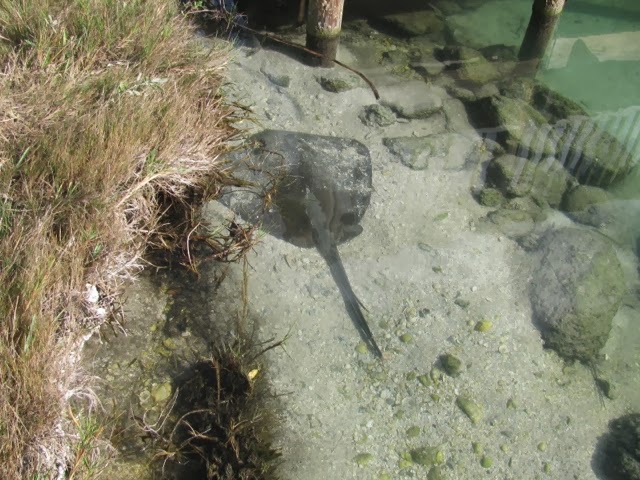
Today (Wednesday) we took a wonderful hike across the island, which is 2.5 miles wide here, to the Atlantic beach. It was windy and cool on the beach, with ugly surf, but we let the dogs run and chase ball/frisbee and had a picnic lunch that included a pound or so of blown sand. The best part was the walk itself, through forests of live oak and palmettos. We saw a wild (feral) hog and also one of these :


Know what that is?
We've also had a couple of close encounters with some of the wild horses on the island, and Riggs spotted an opossum. Here is Sheila trying to text message a horse.
 

After 2 nights here, tomorrow we will make a quick 13 mile run to our last GA port of call, the town of St. Mary's, right on the FLA border. That town might be worth a 2 night stay as well.

One final note : many of the photos in this posting, and throughout the blog, were taken by Sheila on her iPhone. It's great that she always has that available, and she takes some good pictures with it.


Friday, December 6, 2013

Into Georgia

We spent 2 nights at beautiful Beaufort SC, which so far wins our award for nicest waterfront park, with dog friendly landscaping and large swinging benches. On Wednesday we walked the neighborhoods with elegant historic homes and had lunch at Nippys where we ate at a picnic table so the dogs could hang with us. Lots of ball and frisbee play for the dogs too. For Wednesday evening Sheila found us a great bar to visit.


Thursday we had a leisurely morning in Beaufort as we waited for the tidal current to change in a favorable direction. It was 11 am when we pulled anchor, motored down the Beaufort River and rode the ebbing tide (mostly) for 29 miles through more of the SC low country, while sunning on the flying bridge. We passed ritzy Hilton Head Island and finally stopped at the south end of Daufuskie Island. There is an ultra funky bar/restaurant there called Marshside Mama's, and a county dock with 3 hour limit for tie up.


Marshside Mama's is the kind of place you can bring your dog to and let them run off the leash, at least if your dogs aren't the garbage hounds that ours are. While we had a drink or 2 and played 'cornhole', Riggs found his way around back to their garbage area and began feasting while we called for him. Back on the leash for Riggs. A little later we noticed Katie was missing. We had closed the outer gate to the garbage area but she wandered into the restaurant, through the kitchen, and sure enough she found the garbage. If only we could direct their smarts to something productive.


We asked if anyone would mind if we stayed at the county dock overnight and were assured its OK so that allowed us to stay for supper. Fried grouper over cheese grits for me and grilled mahi over pasta for Sheila. If you ignore the grunge (easy for me) the food was great.


Today we made a short 12 mile run to, and up, the Savannah River into Savannah GA. We are at the municipal dock right below busy River Street. Our timing is such that we are going to get the Christmas Spirit, whether we like it or not. Today and tomorrow Savannah holds its 'Christmas on the River' celebration and as we tied up workers were setting up a stage and sound system right next to us. So far we've heard recorded jazzy Christmas music (Vince Guarini), a live barbershop quartet, a mixed choral group, and right now they are showing the holiday classic 'Elf'. Later tonight there will be fireworks, and a host of other entertainment tomorrow, including the Christmas Parade! Also lots of vendor booths set up with food and gift items.


It's all almost enough to distract us from the real show here, which is the Savannah River shipping activity. Averaging maybe 1 per hour, humongous ships pass by about 100 feet away, headed upriver or out to sea. The ships move slowly enough such that their wakes are no big deal. The tugboats and small ferry boat are worse.
Oh, have I mentioned the weather here? Last few days have hit the 70's and today hit 80. Tee shirts and shorts for me and a pretty summer dress for Sheila. Very different weather than what we read about for mid America and warmer than normal for here at this time of year.
 
Current plans are to stay 2 nights here, then back to the ICW to wind southwards through coastal GA.


Wednesday, December 4, 2013

Economic indicator?

That little beauty above is a car carrier heading down the Cooper River in Charleston on Monday. Those purpose-built vessels hold about 5,000 vehicles, in this case BMW SUV's.
I'm not sure if the following tidbit of info is an important economic indicator, but maybe it is. 4 years ago I stayed a week at the Charleston Maritime Center and immediately south of the marina these behemoths came in daily and belched out imported BMW's, including MINI's, which were then transported to the US market. This year the dock to the south is used for cruise ships, but the dock immediately north of the marina has these same behemoths coming and going, but now they are gobbling up South Carolina built BMW SUV's for export (possibly to other US ports).
Coincidentally, the NY Times recently published this article about BMW's South Carolina operation.
Right now, the greater Charleston area is growing fast, and its economy seems healthy to me.

Tuesday, December 3, 2013

Uphill and Downhill

Today we made a long 50 nm run from outside of Charleston to Beaufort SC. The weather was good, and winds were light, so creeks, rivers and sounds were calm, as you can see above. On the other hand, lunar tides were high with 9 ft tides, which we haven't seen since Maine, and the resulting tidal currents were a big factor in our travel.

In this beautiful marshland the ICW winds towards the ocean, then away from the ocean, and repeats. We started at the John's Island Oxbow (photo above) where we had arrived yesterday after a short 12 mile run from Charleston, at roughly high tide. Thus most of our travel today was on an ebbing tide, so when we were headed towards the ocean we had assisting current (downhill run) and when we veered away from the ocean we had opposing current (uphill run).

As we cruised I wondered whether the effect of currents averaged out and so didn't matter. Here's a thought experiment that might edify :

- Lets run Spray at a constant 1500 rpm, which yields a speed of 6 knots in still water. We run a 12 nm route. If the route is in still water it's a 2 hour trip.

- Now split the route in half and add some current. The first 6 nm of the route will have a 2 knot assisting current and the last 6 nm will have a 2 knot opposing current. Will the trip still take 2 hours? What say you?

We need to do the math on each half of the route. The downhill portion covers 6 nm at a rate of 8 knots. Start with Distance = Rate x Time and solve for Time = Distance/Rate = 6 nm/8 knots = 0.75 hours.

The uphill portion takes T = D/R = 6 nm/4 knots = 1.5 hours. Both portions together take 1.5 + 0.75 = 2.25 hours, or 1/4 hour LONGER than with zero currents.

That's why today's run seemed so frustrating. We saw 'speed over ground' range from 9 knots for some downhill runs, down to 4.5 knots for some uphill runs. The downhill runs are over quickly while some of the uphill runs are brutal.

[An interesting extreme case for this exercise uses current speed of 6 knots. Then the downhill run is done at 12 knots and takes a quick 1/2 hour, but for the uphill run Spray is actually stopped and takes infinite time to complete the route.]

Nevertheless, we did end up reaching lovely Beaufort SC at about 4 pm. We had time to explore the town (really nice waterfront park) but we'll spend another day here to see more of it. Stay tuned!


Monday, December 2, 2013

Hard to leave...

We've had a very nice and relaxing week here in Charleston and will be departing at about 1 pm today, at low tide. The dogs will miss daily play of ball and frisbee on the big lawn here and the extended walks around the city. Sheila and I will miss the handy stores and great restaurants, as welll as the leisurely mornings and decent weather (other than Tuesdays' storm). Not to mention all the electricity, fresh water, hot water, shoreside showers, and laundry access we wanted. Pretty luxurious compared to life on the hook.


We stuck to our routine of dog play and walks in the morning then leaving them aboard while we went out for lunch, and puttering aboard Spray in the afternoon. For lunches we went to the following:

- Thursday we did do the Thanksgiving buffet at nearby Saffron Cafe and Bakery. They had a good crowd and the buffet food was quite good. In the old days I would really get my money worth out of the 'all you can eat' aspect but those days are over.

- Friday we went to 'Fish' which is billed as French-Asian with a seafood bent. Sheila thought this might be the best restaurant we've hit on the whole trip.

- Saturday, after a quick wander through the farmers market at Marion Square, we went to the Blackbean Co. and ate fresh spring rolls and wraps.

- Yesterday we attempted an encore run at 'Fast and French' but they are closed on Sunday, so we diverted to Bocci's for bruschetta and pasta.


On Saturday we had a very nice time visiting Nat and Jane Ball, who have deep roots in Charleston and own a summer home in Castine. They are currently staying in a condo just a block from this marina and graciously had us over for drinks and snacks. Southern hospitality is real.


Our walks took us across the Charleston peninsula to check out the large Charleston City Marina with its 1,500 ft Megadock (for mega yachts), down to the south end of the peninsula to the battery park, and through the historic neighborhoods south of Broad Street, full of gorgeous old homes. We watched part of a Christmas parade yesterday. As you can see above, Charleston is ready for Christmas.


Charleston is a beautiful city and was a nice break for us, but its time to continue southwards. A short 12 mile run today to anchor in an oxbow, then on to Beaufort SC tomorrow.


Wednesday, November 27, 2013

Charleston so far

The arrival :

Four years ago when I did this ICW trip with Riggs, the worst sea conditions we encountered were as we entered Charleston Bay on the southbound trip, hitting strong W winds. This time (on Monday) there were also strong winds in the bay, but this time from the NE, so it was more protected to get ourselves into the Charleston Maritime Center, which is city owned and has a small marina.

The marina :

CMC is mostly great:

+ location near French Quarter and downtown is excellent. Lots to do and see within walking distance.

+ price is very reasonable for a city location. The hotels and inns near here are all quite expensive.

+ its well protected from W winds.

+ laundry is free.

+ good size grocery store, produce market, hardware store are all only 3 blocks away.

+ great lawn for dog play.

+ excellent concrete floating docks. Very strong.

but...

- exposed to E winds and to wakes from passing ships. It can get bouncy here.

The storm :

Yesterday afternoon the E exposure and strong docks came into play as the big East Coast Storm came through. The winds started from NE but then slowly clocked to E, SE, SSE, S,... In the mid-afternoon through the evening the winds pushed waves right into the marina and the boats in here were galloping in place. Luckily we had added extra docking lines to Spray (9 lines total) so while she rolled and pitched, she never banged the docks. I did get a lesson on what chafe can do to a dock line :

That line actually got eaten by a roller that guides the floating dock up and down on a piling. Good thing there were backup lines.
The wind was whipping up good too, with lightning storms, downpours, and a tornado watch. It was a rock-and-roll evening and not much fun. Better here than on the hook in some remote creek though.
Later in the evening the wind clocked to towards the west and today we've just had strong W winds, which leave us in the lee so its not bad. Expecting sun and seasonably cool tomorrow.

The dining :
Charleston reminds me of Portland ME. Similar size, lots of history, and a fantastic restaurant scene, that we want to sample. To keep costs reasonable we are eating breakfast and supper aboard Spray, and going out for lunch. Here's where we've gone so far:
Tues. - small place known as 'Fast and French'. Excellent and a neat scene. Sheila's split pea soup was the best either of us had ever tasted.
Wed. - Sheila was craving real hand cut fries so we ended up at Boones Bar and Grill, which is near the university. Beer and food was very good, and the fries were great.
Tomorrow - We have reservations for a Thanksgiving buffet at nearby Saffron Cafe & Bakery. It's supposed to be good and we'll find out.
 
So far our routine here is a relaxed breakfast aboard Spray, then dog play and walking as we'll as laundry and showers, then the dogs camp out while we venture out for lunch and some shopping. Back aboard Spray we read, feed dinner to the dogs, take them for their evening walk, then do supper and read or watch Netflix. Give us some sunnier weather for longer walks and we'll be all set. Planned departure for points south is on Monday.


Monday, November 25, 2013

Into SC

The last blog entry found us in Wrightsville Beach NC at ICW mile marker 283. Now we are at MM 430 in McClellanville SC. What did we encounter in the 150 (statute) miles from there to here?

As you can see above, our departure Thursday morning from Wrightsville Beach was eventful. The day's planned run to Southport NC (MM 309) was short enough to allow time for a hot breakfast aboard Spray and another romp on the beach, this time with tennis ball and frisbee. We then pulled anchor and were wending our way to the ICW channel when that USCG boat lined up beside us to board for a (non-voluntary) safety inspection.
I stayed on the flying bridge and kept Spray on course at 5 knots while 3 of the coasties leapt aboard. Sheila went below to get paperwork (Fed. documentation and rules/regs book) and answer questions. They peeked down in the engine room, verified that we had proper PFD'S, fire extinguishers, and holding tank setup. We passed the inspection with flying colors. The process took maybe 20 minutes and was actually fun.
It was an easy trip to Southport, including a wide portion of the Cape Fear River. We pulled into a vacant (free) slip, walked around the nice downtown area, and had dinner at Yacht Basin Eatery, who had given us the OK to use the slip. On our walk we encountered our 2nd labyrinth of our journey.
Friday we left early for a longer run to Barefoot Marina (MM 354) in North Myrtle Beach SC, crossing the NC/SC border. We walked from the marina, over a bridge, and explored the large Barefoot Landing shopping complex, which is aimed at tourists and so was pretty dead this time of year. Sheila did buy a new pair of reading glasses and took some pictures of critters in the lake the project surrounds.
On Saturday we had another longish run to Georgetown SC (MM 404). In this section the ICW turns inland some through cypress swamps. It was pretty, backwoods country but there was much floating debris, mostly water hyacinths. We had a small break when we pulled into Osprey Marina to buy 100 gallons diesel ($3.45) and continued on our uphill run (we had opposing current almost all day) to Georgetown. It took us 8 hours to make this 45 nm trip, but it was worth it. We dropped the hook in their crowded harbor, about 100 ft. from a town dock, and went exploring.
Sheila says she could actually imagine living in Georgetown. It has real industry - a paper mill and a steel mill, lots of beautiful homes, and a vibrant downtown. They lost a block of waterfront businesses (7 stores) a couple of months ago to a fire, but most of the businesses were already up and running at new locations, including the nice bar/restaurant we had dinner at. The fast recovery is a heartwarming story of community.
Yesterday was windy and cold, and it was a bouncy hour of traveling down wide Winyah Bay until we turned into a narrow cut and continued through the SC 'low country' to McClellanville. Lots of beautiful grassy marshland to see with many shore birds, hawks, and dolphins. This town is gorgeous with huge live oaks draped in spanish moss, although there are very few businesses. We're glad to be tied up at Leland Oil Co. dock with shore power connected as we awoke to 30 degrees this morning and have an electric heater cranking away.
We're now waiting for the sun and tide to rise a bit before heading to Charleston, which is a 33 nm run. We see reports of shoaling at a few inlets so we want to hit those (poor choice of words) during a rising tide. This afternoon we will pull into the Charleston Maritime Center where we will stay a whole week!


Wednesday, November 20, 2013

Today's Travel

Hello from Wrightsville Beach, where we are anchored.


I closed yesterday's blog with a description of our rather complex travels of today, between Swansboro and Wrightsville Beach. I spent some time yesterday scribbling some notes on the planned trip, as shown below:

Allow me to decode the scribbles. At top is our starting location Swansboro, at ICW mile marker MM=229 (mile 0 is in Norfolk VA, and ICW miles are statute miles rather than nautical miles). The four drawbridges are shown : Onslow Beach, Surf City, Figure Eight Island, and Wrightsville Beach, along with their MM's, the distances between them (deltas), and their opening schedules.


The target times start at Wrightville Beach since my goal was to make the 3 pm opening so we could drop anchor here with some daylight left to explore some. The times then are figured backwards based on distances, Spray's expected speed, and opening schedules. By the time I worked the times back to Swansboro, we needed to start out at 6:30 am, which is first light these days. It's good that we were at a marina which made it easier to 'drain the dogs' before we left.
 
You will also see contact info for Camp Lejeune, in case we had issues with crossing their firing range, and the number for Towboats US, in case we had issues with any of the several shoaling areas we would encounter.
 
So here's how we made out :
- Pulled out of Swansboro (MM229) on schedule at 0630.
- Entered Camp Lejeune firing range (MM235) at about 0720. Warning sign had no flashing lights and AM530 (referred to by sign) was silent.
- At MM238 we encountered shoaling near Brown's Inlet, which we had been warned about. Slowed down and threaded S pattern through temporary markers. Saw no depths less than 9 feet so no problem there.
- Continued through Camp Lejeune and started seeing activity such as amphibious vehicles and speeding patrol boats (hey, take some 18 year olds, give them guns, and turn them loose with powerful motor boats - What can go wrong?). Also heard many booms from ranges inland.
- I picked up the pace in hopes of making the Onslow Beach Bridge by its 0800 opening, so we could get ahead of schedule. We arrived at the bridge at 0805 and the operator would not open it. So we dropped the hook right in the channel and had breakfast. We made our scheduled 0830 opening but just to show us who's boss, the operator waited until 0835 to open the bridge.
- The next stretch I knew would be tough. We had not quite 2.5 hours to cover the 20 miles (17.4 nm) to the Surf City Bridge. It all hinged on the currents, which for a while helped us so we moved at 7 to 8 knots, then against us so we couldn't even make 6 knots. I had to push Spray some but we made the 1100 opening right on time.
- So we were right on schedule heading for the Figure Eight Island Bridge, an I thought we could loaf as we had 3 hours to cover 17 sm (we just covered 20 sm in 2.5 hours), but the current was against us and I got greedy, thinking I should try for the 1:30 opening rather than 2:00. I kept Spray at 'upper cruise' speed of 1700 rpm and the current eventually started helping us some so we were lucky to just make the 1:30 opening.
- But so what? We had about 5 sm to cover before the final bridge, but it would open only at 2 pm or 3 pm, and it was 22 minutes until 2. I loafed along thinking that I'd miss the 2 pm opening but it would be OK since the Wrightville Beach Bridge has at least 20 ft clearance at high tide. Spray needs about 23 feet for her top VHF antenna to clear, but the tide was getting low, and that antenna is flexible, so why couldn't I pass under the bridge when it was closed?
- Then things got a bit weird, but in a good way. As we approached this last bridge at about 2:10, I saw that about 6 boats were passing through, and that takes some time, so I radioed the bridge operator and asked if he might hold it open a couple more minutes for me. He said that some work being done on the bridge actually required he hold it open a bit longer, so come on through! Thus we made the 2 pm opening, almost an hour earlier than scheduled!
- So here's the weird part. The same bridge work that allowed Spray to pass through a bit late also had some netting hanging below the bridge, lowering its clearance to 17 ft. Spray never would have made it under and we would have had to make a last minute u-turn against the current and in a narrow channel, then wait until 3 pm to get through.
 
It was a lucky Spray and crew that turned into Wrightsville Beach, dropped anchor at 2:30, and had plenty of time to walk the dogs on their great beach and watch the surfers. Those waves looked rough and I'm glad we have the barrier islands to cruise behind.
 
Tomorrow we leave mid morning and have a short 24 mile cruise to Southport NC. No more drawbridges in NC. HooRay!