Tuesday, December 3, 2013

Uphill and Downhill

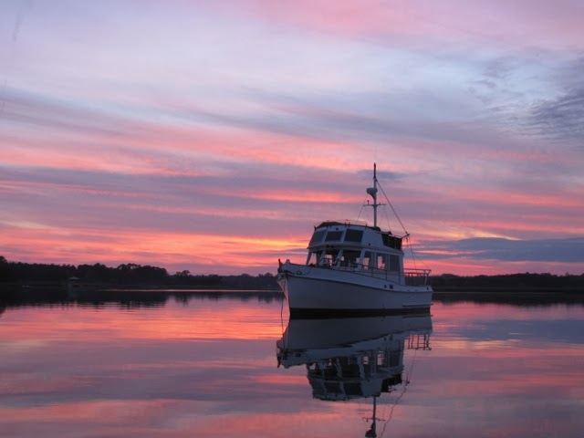
Today we made a long 50 nm run from outside of Charleston to Beaufort SC. The weather was good, and winds were light, so creeks, rivers and sounds were calm, as you can see above. On the other hand, lunar tides were high with 9 ft tides, which we haven't seen since Maine, and the resulting tidal currents were a big factor in our travel.

In this beautiful marshland the ICW winds towards the ocean, then away from the ocean, and repeats. We started at the John's Island Oxbow (photo above) where we had arrived yesterday after a short 12 mile run from Charleston, at roughly high tide. Thus most of our travel today was on an ebbing tide, so when we were headed towards the ocean we had assisting current (downhill run) and when we veered away from the ocean we had opposing current (uphill run).

As we cruised I wondered whether the effect of currents averaged out and so didn't matter. Here's a thought experiment that might edify :

- Lets run Spray at a constant 1500 rpm, which yields a speed of 6 knots in still water. We run a 12 nm route. If the route is in still water it's a 2 hour trip.

- Now split the route in half and add some current. The first 6 nm of the route will have a 2 knot assisting current and the last 6 nm will have a 2 knot opposing current. Will the trip still take 2 hours? What say you?

We need to do the math on each half of the route. The downhill portion covers 6 nm at a rate of 8 knots. Start with Distance = Rate x Time and solve for Time = Distance/Rate = 6 nm/8 knots = 0.75 hours.

The uphill portion takes T = D/R = 6 nm/4 knots = 1.5 hours. Both portions together take 1.5 + 0.75 = 2.25 hours, or 1/4 hour LONGER than with zero currents.

That's why today's run seemed so frustrating. We saw 'speed over ground' range from 9 knots for some downhill runs, down to 4.5 knots for some uphill runs. The downhill runs are over quickly while some of the uphill runs are brutal.

[An interesting extreme case for this exercise uses current speed of 6 knots. Then the downhill run is done at 12 knots and takes a quick 1/2 hour, but for the uphill run Spray is actually stopped and takes infinite time to complete the route.]

Nevertheless, we did end up reaching lovely Beaufort SC at about 4 pm. We had time to explore the town (really nice waterfront park) but we'll spend another day here to see more of it. Stay tuned!


Monday, December 2, 2013

Hard to leave...

We've had a very nice and relaxing week here in Charleston and will be departing at about 1 pm today, at low tide. The dogs will miss daily play of ball and frisbee on the big lawn here and the extended walks around the city. Sheila and I will miss the handy stores and great restaurants, as welll as the leisurely mornings and decent weather (other than Tuesdays' storm). Not to mention all the electricity, fresh water, hot water, shoreside showers, and laundry access we wanted. Pretty luxurious compared to life on the hook.


We stuck to our routine of dog play and walks in the morning then leaving them aboard while we went out for lunch, and puttering aboard Spray in the afternoon. For lunches we went to the following:

- Thursday we did do the Thanksgiving buffet at nearby Saffron Cafe and Bakery. They had a good crowd and the buffet food was quite good. In the old days I would really get my money worth out of the 'all you can eat' aspect but those days are over.

- Friday we went to 'Fish' which is billed as French-Asian with a seafood bent. Sheila thought this might be the best restaurant we've hit on the whole trip.

- Saturday, after a quick wander through the farmers market at Marion Square, we went to the Blackbean Co. and ate fresh spring rolls and wraps.

- Yesterday we attempted an encore run at 'Fast and French' but they are closed on Sunday, so we diverted to Bocci's for bruschetta and pasta.


On Saturday we had a very nice time visiting Nat and Jane Ball, who have deep roots in Charleston and own a summer home in Castine. They are currently staying in a condo just a block from this marina and graciously had us over for drinks and snacks. Southern hospitality is real.


Our walks took us across the Charleston peninsula to check out the large Charleston City Marina with its 1,500 ft Megadock (for mega yachts), down to the south end of the peninsula to the battery park, and through the historic neighborhoods south of Broad Street, full of gorgeous old homes. We watched part of a Christmas parade yesterday. As you can see above, Charleston is ready for Christmas.


Charleston is a beautiful city and was a nice break for us, but its time to continue southwards. A short 12 mile run today to anchor in an oxbow, then on to Beaufort SC tomorrow.


Wednesday, November 27, 2013

Charleston so far

The arrival :

Four years ago when I did this ICW trip with Riggs, the worst sea conditions we encountered were as we entered Charleston Bay on the southbound trip, hitting strong W winds. This time (on Monday) there were also strong winds in the bay, but this time from the NE, so it was more protected to get ourselves into the Charleston Maritime Center, which is city owned and has a small marina.

The marina :

CMC is mostly great:

+ location near French Quarter and downtown is excellent. Lots to do and see within walking distance.

+ price is very reasonable for a city location. The hotels and inns near here are all quite expensive.

+ its well protected from W winds.

+ laundry is free.

+ good size grocery store, produce market, hardware store are all only 3 blocks away.

+ great lawn for dog play.

+ excellent concrete floating docks. Very strong.

but...

- exposed to E winds and to wakes from passing ships. It can get bouncy here.

The storm :

Yesterday afternoon the E exposure and strong docks came into play as the big East Coast Storm came through. The winds started from NE but then slowly clocked to E, SE, SSE, S,... In the mid-afternoon through the evening the winds pushed waves right into the marina and the boats in here were galloping in place. Luckily we had added extra docking lines to Spray (9 lines total) so while she rolled and pitched, she never banged the docks. I did get a lesson on what chafe can do to a dock line :

That line actually got eaten by a roller that guides the floating dock up and down on a piling. Good thing there were backup lines.
The wind was whipping up good too, with lightning storms, downpours, and a tornado watch. It was a rock-and-roll evening and not much fun. Better here than on the hook in some remote creek though.
Later in the evening the wind clocked to towards the west and today we've just had strong W winds, which leave us in the lee so its not bad. Expecting sun and seasonably cool tomorrow.

The dining :
Charleston reminds me of Portland ME. Similar size, lots of history, and a fantastic restaurant scene, that we want to sample. To keep costs reasonable we are eating breakfast and supper aboard Spray, and going out for lunch. Here's where we've gone so far:
Tues. - small place known as 'Fast and French'. Excellent and a neat scene. Sheila's split pea soup was the best either of us had ever tasted.
Wed. - Sheila was craving real hand cut fries so we ended up at Boones Bar and Grill, which is near the university. Beer and food was very good, and the fries were great.
Tomorrow - We have reservations for a Thanksgiving buffet at nearby Saffron Cafe & Bakery. It's supposed to be good and we'll find out.
 
So far our routine here is a relaxed breakfast aboard Spray, then dog play and walking as we'll as laundry and showers, then the dogs camp out while we venture out for lunch and some shopping. Back aboard Spray we read, feed dinner to the dogs, take them for their evening walk, then do supper and read or watch Netflix. Give us some sunnier weather for longer walks and we'll be all set. Planned departure for points south is on Monday.


Monday, November 25, 2013

Into SC

The last blog entry found us in Wrightsville Beach NC at ICW mile marker 283. Now we are at MM 430 in McClellanville SC. What did we encounter in the 150 (statute) miles from there to here?

As you can see above, our departure Thursday morning from Wrightsville Beach was eventful. The day's planned run to Southport NC (MM 309) was short enough to allow time for a hot breakfast aboard Spray and another romp on the beach, this time with tennis ball and frisbee. We then pulled anchor and were wending our way to the ICW channel when that USCG boat lined up beside us to board for a (non-voluntary) safety inspection.
I stayed on the flying bridge and kept Spray on course at 5 knots while 3 of the coasties leapt aboard. Sheila went below to get paperwork (Fed. documentation and rules/regs book) and answer questions. They peeked down in the engine room, verified that we had proper PFD'S, fire extinguishers, and holding tank setup. We passed the inspection with flying colors. The process took maybe 20 minutes and was actually fun.
It was an easy trip to Southport, including a wide portion of the Cape Fear River. We pulled into a vacant (free) slip, walked around the nice downtown area, and had dinner at Yacht Basin Eatery, who had given us the OK to use the slip. On our walk we encountered our 2nd labyrinth of our journey.
Friday we left early for a longer run to Barefoot Marina (MM 354) in North Myrtle Beach SC, crossing the NC/SC border. We walked from the marina, over a bridge, and explored the large Barefoot Landing shopping complex, which is aimed at tourists and so was pretty dead this time of year. Sheila did buy a new pair of reading glasses and took some pictures of critters in the lake the project surrounds.
On Saturday we had another longish run to Georgetown SC (MM 404). In this section the ICW turns inland some through cypress swamps. It was pretty, backwoods country but there was much floating debris, mostly water hyacinths. We had a small break when we pulled into Osprey Marina to buy 100 gallons diesel ($3.45) and continued on our uphill run (we had opposing current almost all day) to Georgetown. It took us 8 hours to make this 45 nm trip, but it was worth it. We dropped the hook in their crowded harbor, about 100 ft. from a town dock, and went exploring.
Sheila says she could actually imagine living in Georgetown. It has real industry - a paper mill and a steel mill, lots of beautiful homes, and a vibrant downtown. They lost a block of waterfront businesses (7 stores) a couple of months ago to a fire, but most of the businesses were already up and running at new locations, including the nice bar/restaurant we had dinner at. The fast recovery is a heartwarming story of community.
Yesterday was windy and cold, and it was a bouncy hour of traveling down wide Winyah Bay until we turned into a narrow cut and continued through the SC 'low country' to McClellanville. Lots of beautiful grassy marshland to see with many shore birds, hawks, and dolphins. This town is gorgeous with huge live oaks draped in spanish moss, although there are very few businesses. We're glad to be tied up at Leland Oil Co. dock with shore power connected as we awoke to 30 degrees this morning and have an electric heater cranking away.
We're now waiting for the sun and tide to rise a bit before heading to Charleston, which is a 33 nm run. We see reports of shoaling at a few inlets so we want to hit those (poor choice of words) during a rising tide. This afternoon we will pull into the Charleston Maritime Center where we will stay a whole week!


Wednesday, November 20, 2013

Today's Travel

Hello from Wrightsville Beach, where we are anchored.


I closed yesterday's blog with a description of our rather complex travels of today, between Swansboro and Wrightsville Beach. I spent some time yesterday scribbling some notes on the planned trip, as shown below:

Allow me to decode the scribbles. At top is our starting location Swansboro, at ICW mile marker MM=229 (mile 0 is in Norfolk VA, and ICW miles are statute miles rather than nautical miles). The four drawbridges are shown : Onslow Beach, Surf City, Figure Eight Island, and Wrightsville Beach, along with their MM's, the distances between them (deltas), and their opening schedules.


The target times start at Wrightville Beach since my goal was to make the 3 pm opening so we could drop anchor here with some daylight left to explore some. The times then are figured backwards based on distances, Spray's expected speed, and opening schedules. By the time I worked the times back to Swansboro, we needed to start out at 6:30 am, which is first light these days. It's good that we were at a marina which made it easier to 'drain the dogs' before we left.
 
You will also see contact info for Camp Lejeune, in case we had issues with crossing their firing range, and the number for Towboats US, in case we had issues with any of the several shoaling areas we would encounter.
 
So here's how we made out :
- Pulled out of Swansboro (MM229) on schedule at 0630.
- Entered Camp Lejeune firing range (MM235) at about 0720. Warning sign had no flashing lights and AM530 (referred to by sign) was silent.
- At MM238 we encountered shoaling near Brown's Inlet, which we had been warned about. Slowed down and threaded S pattern through temporary markers. Saw no depths less than 9 feet so no problem there.
- Continued through Camp Lejeune and started seeing activity such as amphibious vehicles and speeding patrol boats (hey, take some 18 year olds, give them guns, and turn them loose with powerful motor boats - What can go wrong?). Also heard many booms from ranges inland.
- I picked up the pace in hopes of making the Onslow Beach Bridge by its 0800 opening, so we could get ahead of schedule. We arrived at the bridge at 0805 and the operator would not open it. So we dropped the hook right in the channel and had breakfast. We made our scheduled 0830 opening but just to show us who's boss, the operator waited until 0835 to open the bridge.
- The next stretch I knew would be tough. We had not quite 2.5 hours to cover the 20 miles (17.4 nm) to the Surf City Bridge. It all hinged on the currents, which for a while helped us so we moved at 7 to 8 knots, then against us so we couldn't even make 6 knots. I had to push Spray some but we made the 1100 opening right on time.
- So we were right on schedule heading for the Figure Eight Island Bridge, an I thought we could loaf as we had 3 hours to cover 17 sm (we just covered 20 sm in 2.5 hours), but the current was against us and I got greedy, thinking I should try for the 1:30 opening rather than 2:00. I kept Spray at 'upper cruise' speed of 1700 rpm and the current eventually started helping us some so we were lucky to just make the 1:30 opening.
- But so what? We had about 5 sm to cover before the final bridge, but it would open only at 2 pm or 3 pm, and it was 22 minutes until 2. I loafed along thinking that I'd miss the 2 pm opening but it would be OK since the Wrightville Beach Bridge has at least 20 ft clearance at high tide. Spray needs about 23 feet for her top VHF antenna to clear, but the tide was getting low, and that antenna is flexible, so why couldn't I pass under the bridge when it was closed?
- Then things got a bit weird, but in a good way. As we approached this last bridge at about 2:10, I saw that about 6 boats were passing through, and that takes some time, so I radioed the bridge operator and asked if he might hold it open a couple more minutes for me. He said that some work being done on the bridge actually required he hold it open a bit longer, so come on through! Thus we made the 2 pm opening, almost an hour earlier than scheduled!
- So here's the weird part. The same bridge work that allowed Spray to pass through a bit late also had some netting hanging below the bridge, lowering its clearance to 17 ft. Spray never would have made it under and we would have had to make a last minute u-turn against the current and in a narrow channel, then wait until 3 pm to get through.
 
It was a lucky Spray and crew that turned into Wrightsville Beach, dropped anchor at 2:30, and had plenty of time to walk the dogs on their great beach and watch the surfers. Those waves looked rough and I'm glad we have the barrier islands to cruise behind.
 
Tomorrow we leave mid morning and have a short 24 mile cruise to Southport NC. No more drawbridges in NC. HooRay!
Tuesday, November 19, 2013

Dock to dock to dock

Since the last blog entry from Belhaven NC we have visited three more nice NC towns, and stayed at docks at all of them.


On Saturday we left Belhaven in the fog, and I got to use Spray's radar as we went down the remainder of the Pungo River. The sun burned off the fog by the time we crossed the Pamilico River and entered a system of creeks and canals to enter Pamlico Sound and then turn into the Neuse River. Our destination was Oriental NC which has free dock space for 2 boats, with a webcam pointed at the dock so I could check to see if there was free space as we approached. I figured our chances were low since Oriental is a very popular stop for ICW cruisers but amazingly the 2 boats that were there left just before we arrived so we had our choice of free dock space.


Just as we finished tying up, our friends Scott and Lynn from Castine pulled up in their car. They have recently purchased a condo in nearby New Bern and so we had planned a visit. They have spent much time in Oriental in recent years, living on their sailboat, and so directed us on a walking tour of the town. We had a nice supper with them at M & M's restaurant that night. Here we all are at a great coffee shop:


I really wanted to spend 2 nights at Oriental but the weather prediction called for easy cruising on Sunday and windy conditions on Monday, so on Sunday, after coffee and scones at the Bean, and another walk around town, we fair-weather sailors departed Oriental, again in foggy conditions. It was challenging to cross the Neuse River and enter Adams Creek with near zero visibility and some other vessel traffic. The fog cleared in Adams Creek and we had an easy ride straight south to Beaufort NC, returning to near the Atlantic Shore. I had reserved a slip for 2 nights at Beaufort Docks Marina which is perfectly sited at the center of the waterfront. They serve only transient boaters with 90 slips and were host to some amazing yachts, as well as Spray.


So in lovely Beaufort we had plenty of time to explore, visit a bar and restaurant, and Sheila did some laundry. We took our dinghy across to Carrot Island for some hiking and saw the wild horses that live there (photo below). We left early today (Tuesday) to catch favorable tide as we crawled down Bogue Sound in strong N winds to the town of Swansboro NC, where we are the only boat at Caspers Marina. We arrived early enough for some dog walking, some shopping, and a light dinner at an Irish Pub.


Tomorrow we have a very challenging day. We will leave at first light, work our way through some serious shoaling near inlets and cross a section of USMC Camp Lejeune where they do live fire right across the ICW. I called their fire control officer today and was told that we could pass only during odd hours : 7-8 is OK but 8-9 is not. We also must deal with 4 drawbridges that open only at scheduled times, like only on the hour. If you arrive at 11:05 you must wait until 12:00 to get under the bridge. Plus it's a long day (for us) of almost 50 miles to our goal of Wrightsville Beach NC. Stay tuned to see how it goes.


Friday, November 15, 2013

Gum Neck Creek

On Thursday we departed Elizabeth City NC at 0630, along with 6 other boats. Down the remainder of the Pasquotank River and then 12 miles across Albemarle Sound, where the predicted 5-10 knot SW wind and 1 ft waves was actually 15 knots and 3 ft steep chop on our starboard beam. That made for 2 hours of no fun.

Conditions calmed down as we entered the Alligator River on which we cruised 18 miles south, then hooked westwards. At the top of the Alligator-Pungo Canal we diverted from the ICW, continuing a mile along the Alligator to anchor off of Piney Point. Total distance traveled was about 48 miles.
This was a very remote and beautiful anchorage. Zero AT&T coverage and intermittent Verizon coverage. Surrounded by scrubby swampland that made landing the dogs impractical, EXCEPT that we happened to be across from a little hidden creek that snaked into the swamp to end at Gum Neck Landing, a state boat ramp.

Taking the dinghy up there was kind of magical. Here are some pix.

First the creek entrance. Without those markers it would be impossible to find.
The dogs are excited. Note that they are wearing cold weather garb and that Riggs is leashed in case he tries to bolt after some critter.
As we enter the creek we are warned about submerged stumps, etc. We proceed very slowly.
We motor up the creek, which is perfectly still.
At creek's end is a half sunk boat and a small dock, which we tie onto.
Yes this is civilization. There is even grass for the dogs.
We walk inland a bit and discover we're in farm country.
So we visited the landing Thursday afternoon and again Friday morning. Then we pulled anchor, cruised back to the ICW, and entered the Alligator-Pungo Canal, a 20 mile ditch through more swampland and forests.
The canal put us in the Pungo River and in another hour or so we pulled into Belhaven NC and dropped anchor. We had time for a walking tour of the town, took the dogs back to Spray, and then we humans spent some Yankee dollars at a new tavern and then a new fancy restaurant. Sweet.
Today we cross Pamlico Sound and cruise on to Oriental NC.