Wednesday, November 13, 2013

Welcome to North Carolina!

So this past Monday we left Hampton VA and crossed the Hampton Roads shipping channel, then cruised past the Norfolk navy facilities (largest in the world!). Here is the USS George H.W. Bush, last of the Nimitz class super carriers (cost = $6.2 billion) :

Notice the Navy patrol boat keeping a close eye on us as we passed. Maybe I shouldn't have broadcast 'praise to Allah' on the VHF as we approached.
 
We wound our way through Norfolk/Portsmouth VA, bought 100 gallons of diesel at Top Rack Marina ($3.39/gal which is a great price), then turned down Deep Creek to enter a lock to raise us 8 ft onto the Dismal Swamp Canal. Here are some pix:
 
In the lock with 3 other boats.
Mileage sign indicates that we have far to go.
Katie Bopp relaxes as Spray is lifted...
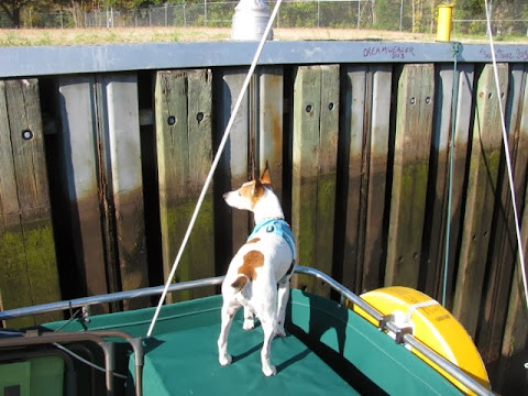
While Riggs supervises.
The lock gates open.
And we cruise down the canal.
After 15 miles or so we cross from VA into NC then shortly after stop at the NC welcome facility, which is unique in serving both a highway and a waterway. We tied to their wall overnight.
On Tuesday we get an early start to complete the final 5 miles of the canal, then at 9 am we lock down to approximate sea level again on the Pasquotank River. The next 15 miles were winding through beautiful cypress swamp until we arrived here in Elizabeth City NC.
They really mean that hospitality stuff as they have much free dockage for transient boaters which was important to us since as soon as we arrived the weather turned nasty: cold with strong north winds. It actually snowed some last night and this morning we had ice on the decks. Nice to be securely tied up and not have to deal with the dinghy.
We've been returning their favors by hitting restaurants and bars (which have heat!). I went to a nearby gym yesterday for a hot shower, and Sheila got a southern style (think big hair) haircut today.
Right now our new best friend
is cranking away, trying to heat our salon.
Tomorrow we leave at first light to head south and cross Albermarle Sound. We should be anchoring in one of the remotest spots on the entire ICW.


Sunday, November 10, 2013

Southern Chesapeake

Chesapeake Bay is the largest estuary in the US, almost 200 miles from where we entered via the C&D Canal down to the Hampton Roads inlet near Norfolk VA. You could spend years cruising the waters of the Chesapeake and not have time to see it all. Sadly we don't have that much time and so we needed to push southwards rather quickly (for us) through the lower half of the Chesapeake.

It was this past Tuesday that wind conditions allowed us to leave St. Michaels MD and move down and across the bay to Solomons MD where we anchored off of Zahnisers boatyard.

We paid a few dollars to use their dinghy dock and showers and were able to buy a bag of good dog food (at least the dogs like it) at a nearby store.

On Wednesday we moved down the bay some more, crossing the wide mouth of the Potomac River and landing in beautiful Reedville VA, home of a menhaden fishing fleet and processing facility. Apparently there is or was money in menhaden, as evidenced by the spectacular old homes in Reedville.

We did get exposed to the smell of the processing plant. Didn't smell like money to me.

On Thursday we moved farther south to James Creek at Deltaville VA.

We anchored at Deltaville for 2 nights as there were strong NW winds, plus we had earned a break. The nearby 'State Dock' was a challenge to climb onto for us geezers but we made do. Then we needed to walk a ways to get to any stores, etc. but that's OK.

Finally on Saturday we made the run down to the Hampton Roads inlet and turned to starboard up the Hampton River, where we stopped at the Hampton VA Public Piers for a water fill up and holding tank pumpout (such things are VERY important), then moved upstream a bit more to drop the anchor. Again we stay 2 nights to give us time to explore this nice small city and buy groceries. Here's the view from our anchorage.
Tomorrow (Monday) should be a big day, as we will cross the Hampton Roads waterway, pass the worlds largest naval facility at Norfolk, enter the official ICW at mile 0, then turn into Deep Creek where a lock will raise Spray by 8 feet to enter the Dismal Swamp Canal. it should be a great adventure so please stay tuned to see how it plays out.


Thursday, November 7, 2013

Blimp. And a birthday!

When we cruised to Solomons MD on Tuesday we saw a US Navy blimp out over the Chesapeake. It was out again the next morning as we departed Solomons, and came close enough for a few photos :

Also, today, November 7, is the birthday of one of Spray's crew. Here he is right after we dropped anchor today in Deltaville VA, very anxious to go to shore.
Riggs is 7 years old today. Middle aged. To celebrate we spoiled him rotten, just like any other day.


Wednesday, November 6, 2013

Oh yeah, the oysters.

The last blog posting was titled 'Oyster Fest' and while I did describe the St. Michaels oyster festival some, as my dear Uncle Larry pointed out in the comments section I never mentioned how the oysters were.

I'm not a huge oyster fan but the few that I tried were pretty good, if you like that sort of thing. Certainly at the festival a ton of oysters were consumed, mostly raw but also in stews and fritters, and people seemed to like them.

Sheila braved the long line to taste 6 samples of oyster stew from local restaurants and vote on her favorite (sample D). We'll have to check which one won.

I was more impressed with the various traditional boats used to harvest oysters. For example, at the festival the museum relaunched the restored skipjack Rosie Parks, originally launched in 1955 :

Apparently these restored skipjacks are not just museum pieces. When we cruised from St Michaels to Solomons yesterday I was pleased to see another skipjack out in the bay, being propelled by its pushboat :

A while later I was really surprised to see yet another skipjack working as intended - pulling an oyster dredge :

As we learned in the museum, oystering in the Chesapeake is a pale shadow of what it was even 25 years ago but it still goes on, albeit with big restrictions on when and where harvesting is permitted. We've seen a few areas posted as oyster nurseries, meaning no harvesting allowed there.


Sunday, November 3, 2013

Oyster Fest

This past Tuesday we left Baltimore and cruised down the Patapsco River then south in the Chesapeake, passed under the Chesapeake Bay Bridge (which is really two bridges), turned right up the Severn River, finally into Spa Creek to the Annapolis mooring field. Since we are post-season most of the rental moorings were free so we chose one close to the town dinghy dock.

We had never visited Annapolis before and while we expected a boaters' haven, which it is, I was surprised how large the city is and that its the Maryland State Capitol (who knew?). The historic buildings are beautiful and packed tightly together. We had to walk a ways to find green space for the pooches. Lots of shops, restaurants, bars, etc.

I probably should have picked a different mooring as ours was exposed to waves from the river/bay and we had a rolly night. Since Wednesday had good cruising weather predicted while Thursday didn't, we stayed in Annapolis just the one night. We left about noon Wednesday at about the same time as the Pride of Baltimore II. We cruised down the Severn and angled south down the Bay while the Pride hoisted sails and turned up the bay to sail to Chestertown for the Downrigging Weekend.
Conditions were OK for cruising to St. Michaels MD, although you need to go way south around one point, then back north around another, then south again in the Miles River. We anchored in Fogg Cove, right off the grounds of the Chesapeake Bay Maritime Museum. The plan was to stay until at least Saturday for their annual Oyster Festival, which is a big deal here. A quick cost/benefit calculation prompted us to buy a 1-year family membership at the Museum, yielding these perks:
- Use of their dinghy dock and 24 hr. access to their grounds.
- Ability to tour their excellent exhibits at leisure.
- Free entrance to the Oyster Festival for us and guests.
- Unlimited use of their HOT SHOWER facilities.
It was a no-brainer. Plus we can use same perks on our return trip northwards.
 
So we had 2 full days to explore St. Michaels and the museum, which was real nice. Sheila is taken by their octagonal Chesapeake light house, which used to sit on screw piles out in the bay.
 
On Saturday my niece and her husband, Michelle and Dave Homsher, drove down Saturday from their new home north of Philly and joined us for the Oyster Festival (good weather - huge crowds - quite the success) and tasting some local beer and seafood in town. They brought us some much appreciated supplies :
 
- 24 cans of this (official cruise 2013/14 beer)
- and a rare bottle of this (proof of why grapes dominate in wine making?)
It was great fun to see them and catch up on their lives.
 
We would have left on Sunday to continue southwards, but high winds have kept us here for 2 extra days, and it will be tomorrow that we head farther down the Bay to Solomon's MD, which is about halfway down the bay on the western shore. As great as exploring the Chesapeake is, we are anxious to get all the way down to Norfolk VA and into the official ICW. We'll see what the weatherman says.
 
Here is Spray anchored in Fogg Cove.


Monday, October 28, 2013

Baltimore!

Since last blog entry we've been exploring the upper Chesapeake, with stops in the middle of nowhere and in the middle of somewhere. Again, wind and waves have impacted our travels.
 
Last Wednesday we left Chesapeake City in the afternoon and turned west in the C & D Canal which soon widened into the upper Chesapeake Bay. A NW wind came up putting waves on our beam, so we 'tacked' a few times until we reached the mouth of the Sassafras River to port. We traveled 3 miles up the river until we turned into Turner Creek. The entrance there is tight, and keeping green markers to port seems like it'll put you in the woods, but it works. We anchored with about 2' of water below Spray's keel.
 
Turner Creek was beautiful, which is a good thing since windy conditions kept us there for 3 nights when we had planned on 2. A very short row away was Turner Creek County Park, with a grassy area for dog play. You can sort of see the park pavilion below.
On Thursday we hiked (and hiked!) through woods and between corn fields. We tried moving on Friday morning at first light since the NOAA marine forecast called for small craft advisory starting at 9 am so we hoped for a couple hours of relative calm to move 12 miles down the bay. Nope. We were barely into the Sassafras when we hit 3+ ft. waves and knew it would be worse out in the bay, so we executed what Jeff Siegel calls the most difficult maneuver in boating : the U-turn. Easy physically but not psychologically. Back into Turner Creek, dropped our anchor in the same hole it had left, and had pancakes cooking by 8:30. Spent the day in the park and loafing on the boat.
 
It was Saturday morning that we finally resumed travel down the Bay, but not very far. We were planning on making it to Baltimore but after a calm start the wind and waves began building so we bailed out into Fairlee Creek, which also has a challenging entrance. Fairlee is a long and wide 'creek' (what we call coves and harbors in Maine are usually called creeks here) and I foolishly dropped the anchor right in the middle of it so we were exposed to some chop. Not bad for Spray but it made for a bumpy dinghy ride to a protected beach. We walked the area for a few hours (soybeans here) and watched the scene at the local marina as people put their boats to bed for winter.
 
So it was Sunday (yesterday) that let us get out of Fairlee Creek, down the Bay some, then a right turn up the Patapsco River and cruise 10 miles up to Baltimore, aka 'Charm City'. We did a short tour up to the head of the harbor, then back down to the Canton neighborhood where we pulled into Anchorage Marina, which is large and well situated. Hot showers and shopping were quickly accomplished.
 
Today the 4 of us walked Baltimore's impressive shore path up to the inner harbor, had lunch here, then I minded the dogs while Sheila toured this. Quite a different environment from the rural creeks of recent days. The weather was the best we've seen in a few weeks and we all like Baltimore. Tonight we left the dogs guarding Spray (by sleeping apparently) and went restaurant/bar hopping in the neighborhood in an attempt to satisfy some of Sheila's cravings :
- for fried oysters and beer we went here
- for hand-cut French fries and beer we went here
- for apple pie and coffee we went here
 
Tomorrow we head back down the Patapsco, then only a few miles down the Bay to the boaters haven of Annapolis, which we're looking forward to.


Wednesday, October 23, 2013

Entering Chesapeake Bay

While we still have good internet access I'll post our travels since Atlantic City:

Sunday night we had a calm stay at the Brigantine anchorage across the Absecom channel from Atlantic City. The pooches really liked the sandy point at the entrance to our anchorage. Monday was a calm sunny day, perfect for going outside and cruising off the beach for 35 miles down to Cape May NJ. The only downside to that cruise was the tide timing as we had 3 knot opposing (flood) current to fight getting out the Absecom Inlet, then 2 knot opposing (now ebb) current getting into the Cape May inlet.

Monday night we splurged for a marina slip at the South Jersey Marina, which is the closest one in Cape May for a walk downtown, which is what we did after we were settled in. Cape May is a beach resort town and quite nice even though its post season so 2/3 of the stores were closed up. The town must be hopping in Summer. Staying at the marina allowed us to take long hot showers, do laundry (they have cool equipment that emails you when your loads are done), and to depart with full water and empty holding tanks, which are all good things. We also enjoyed great Mexican food at '5 de Mayo' across from the marina.

Yesterday we departed the marina at first light (which is 7 am now), crossed the Cape May peninsula via the canal, and were spit out into lower Delaware Bay, where we turned right and headed up the bay for a long slog in choppy conditions (waves were from abeam which we don't like). Fortunately, and for the first time, the tides timed perfectly for us, giving us a 1-2 knot boost for all of the 48 miles up the bay, plus for the 12 miles in the C & D canal, which connects Chesapeake and Delaware Bays, until at 3:30 we ducked into the lagoon here at Chesapeake City MD.

Four years ago when I anchored here Spray was the only boat but this time we shared the small lagoon with 7 cruising sailboats (5 of which were from Canada), so space was a bit tight. They have 2 dinghy docks here, one at the town and one at a grassy park. After 60+ miles aboard Spray (longest passage of the trip so far) the dogs were most happy to hit that park. After walking the town (at least a dozen gift shops, zero food stores) we, all 4 of us, dined al fresco at the Chesapeake Inn for supper.

This morning we played in the park, walked around more, and generally loafed until the current in the canal becomes favorable to continue on into the Chesapeake. We are aiming for Turner Creek, off the Sassafras River, about 20 miles from here. That is a very rural area so we'll see if we have Internet coverage there.